
")
")


Silvretta
Interesting bouldering area for problems from 7a to 7c and starting from 8a (Fontainebleau grades).
Best time(s) :
- January
- February
- March
- April
- May
- June
- July
- August
- Sept.
- Oct.
- Nov.
- Dec.
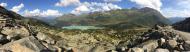
Aspect(s) : All Altitude : 2150 m
Approach between 20 and 40 min on chair lift. Kids friendly ? area around the boulders uneven for young kids.
Informations :
More than 100 problems, from 5c to 8c , spread over many areas Bolting : sport climbing
Max Height : 10 m.
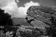
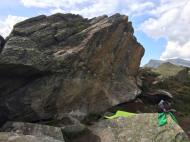
Rock :
gneiss. Characteristic(s) : vertical  , steep wall
  , overhang
  . Type(s) of holds : crimps, cracks, slopers.
Landing quality : uneven or steep ground (1 crash pad and 1 spotter needed).
Legendary problem(s) :
Anam Cara 8b+ F.A. Bernd Zangerl nov 2007
Shining 8a 5th 8a's female boulder by Barbara Zangerl on 1 sept 2004.
Zwiederwurtz 8a/8a+ sent by Barbara Zangerl on 2008.
Ragman 8a/8a+ sent by Karoline Sinnhuber on 31 aug 2019.
X-Ray 8a+ 5th 8a+'s female boulder by Barbara Zangerl on 22 june 2005.
Freerunner 8a+ sent by Angela Eiter on 8 july 2010. Others outstandings sends : Karoline Sinnhuber (2015), Sylwia Buczek (2015).
Pretty Belinda 8a+ sent by Angela Eiter on 8 july 2010.
Charity Bouldern 8a+ sent by Katharina Saurwein on 10 oct 2014. Others outstandings sends : Karoline Sinnhuber (2015), Juliane Wurm (2015), Karoline Sinnhuber (2024).
Rombuk 8a+ sent by Karoline Sinnhuber on 17 june 2021.
Ragman 2.0 8a+ sent by Tabitha Eckfeld on 14 aug 2021.
Nepomuk 8a+ sent by Karoline Sinnhuber on 2 sept 2023.
Alexandra Zimalis 8a+ sent by Karoline Sinnhuber on 19 dec 2021.
Sundance sit 8a+ sent by Karoline Sinnhuber on 12 march 2021.
Skiroute Project 8b sent by Karoline Sinnhuber on 20 july 2016.
More Shining 8b sent by Karoline Sinnhuber on 2 aug 2021.
Memento 8b+ 3rd 8b+'s boulder by Bernd Zangerl on 5 aug 2005. Firsts repeats : Bernhard Schwaiger (2007), Kornelius Obleitner (2008), Kilian Fischhuber (2008), Akito Matsushima (2008), Daniel Woods (2011).
Anam Cara Low 8c first ascent by Lukas Mayerhofer on 3 july 2024
Anam Cara 8b+ F.A. Bernd Zangerl nov 2007
Further information(s) : Thoses who don't like hikking can also use the chairlift from Wirl (summer 2012 price : 7€ two-way).
Locations :
Area :
Austria, Land Tirol, Bezirk Landeck, Landeck, Galtür.
|
|
Latitude : 46° 57' 42" N | Longitude : 10° 8' 3" E | Sexagesimal & Orientation |
|
|
Latitude : 46° 58' 13" N | Longitude : 10° 8' 49" E | Sexagesimal & Orientation |
| More coordinates |
VIDEOS
Area added by CA


