")
")


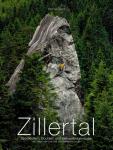
Zillertal (Ginzling Wald)
Interesting bouldering area for problems from 6a to 6c, from 7a to 7c and starting from 8a (Fontainebleau grades).
Best time(s) :
- January
- February
- March
- April
- May
- June
- July
- August
- Sept.
- Oct.
- Nov.
- Dec.
Aspect(s) : All Altitude : 1050 m
Approach between 5 and 10 min easy up hill. Kids friendly ? area around the boulders comfortable for young kids.
Informations :
Between 50 and 100 problems, from 5b to 8b. Bolting : sport climbing
Max Height : 6 m.
Rock :
gneiss. Characteristic(s) : steep wall  , vertical
  . Type(s) of holds : crimps, slopers.
Landing quality : uneven or steep ground (1 crash pad and 1 spotter needed).
Legendary problem(s) :
Sundance (sit) 8a+ sent by Katharina Saurwein on 16 oct 2014. Others outstandings sends : Eva Hammelmüller (2020).
No Lazy Tendons 8a+ sent by Karoline Sinnhuber on 23 april 2025
Locations :
Area :
Austria, Land Tirol, Bezirk Schwaz, Innsbruck, Maryhofen.
|
|
Latitude : 47° 6' 8" N | Longitude : 11° 48' 41" E | Sexagesimal & Orientation |
|
|
Latitude : 47° 6' 4" N | Longitude : 11° 48' 37" E | Sexagesimal & Orientation |
| More coordinates |
Area added by CA