
")
")


Tréménal
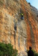
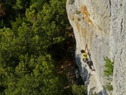
Interesting rock climbing area for routes from 6a to 6c and from 7a to 7c (french grades).
Best time(s) :
- January
- February
- March
- April
- May
- June
- July
- August
- Sept.
- Oct.
- Nov.
- Dec.
Aspect(s) : NW-W Altitude : 300 m
Approach 5 min on flat ground. Kids friendly ? foot of the crag uneven for young kids.
Informations :
More than 100 routes, from 4b to 7c. Bolting : sport climbing
Max Height : 20 m.
Rock :
limestone. Characteristic(s) : steep wall  , vertical
  . Type(s) of holds : pockets / holes, crimps.
We liked this/these route(s) : Cathy by night 6c ; X'exit 6c+
Locations :
Area :
France, Occitanie, Hérault (34), Narbonne, Vialanove.
|
|
Latitude : 43° 22' 19" N | Longitude : 2° 47' 18" E | Sexagesimal & Orientation |
|
|
Latitude : 43° 22' 38" N | Longitude : 2° 47' 36" E | Sexagesimal & Orientation |
| More coordinates |
Area added by CA


