
")
")


Red Rock Canyon Open Space

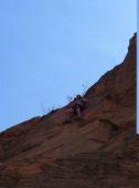
Interesting rock climbing area for routes up to 5c, from 6a to 6c and from 7a to 7c (french grades).
Best time(s) :
- January
- February
- March
- April
- May
- June
- July
- August
- Sept.
- Oct.
- Nov.
- Dec.
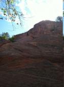
Aspect(s) : All Altitude : 1950 m
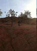
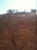
Approach between 15 and 20 min on flat ground. Kids friendly ? foot of the crag reasonable for young kids.
Informations :
Between 50 and 100 routes, from 5.4 to 5.12d , spread over many crags Bolting : sport climbing
Max Height : 30 m.
Rock :
sandstone. Characteristic(s) : vertical  , slab
  . Type(s) of holds : crimps.
Trained technical climbers are required to register at the "Garden of the Gods" visitor center.
Locations :
Area :
United States, Colorado, El Paso County, Denver, Colorado Springs.
|
|
Latitude : 38° 50' 41" N | Longitude : 104° 52' 58" W | Sexagesimal & Orientation |
|
|
Latitude : 38° 51' 7" N | Longitude : 104° 52' 40" W | Sexagesimal & Orientation |
| More coordinates |
Area added by CA


