Pointe Icare
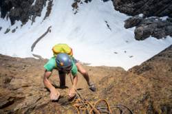
Interesting rock climbing area for routes from 7a to 7c (french grades).
![Information](/images/attention.png)
Many additional skills about progressing, belaying, escaping technics ... are necessary for multipitch routes security.
Best time(s) : - January
- February
- March
- April
- May
- June
- July
- August
- Sept.
- Oct.
- Nov.
- Dec.
Aspect(s) : S Altitude : 2700 m
Approach 120 min steep up hill. Kids friendly ? foot of the crag dangerous for young kids.
Informations :
Less than 10 routes, from 6b to 6c. Bolting : big run out climbing
Max Height : 150 m.
Rock :
granite.
Characteristic(s) : vertical
![Vertical](/images/vertical.png)
, slab
![Dalle](/images/dalle.png)
.
Type(s) of holds : crimps, cracks.
Further information(s) : 1 voie : Le Rêve d'Icare 140 m TD 6b+
Locations :
Area :
France, Auvergne-Rhône-Alpes, Haute-Savoie (74), Annecy, Chamonix-Mont-Blanc, Hameau du Buet.
![Information](/images/readme.png)
1. Zoom in to get all the rock climbing places 200 km around.
![](/images/mm_20_green.png)
: Bouldering
![](/images/mm_20_orange.png)
: Single pitch
![](/images/mm_20_red.png)
: Multi pitches
![](/images/mm_20_blue.png)
: Deep water soloing
![](/images/mm_20_white.png)
: Differents kind of climbing
Rock climbing area GPS Coordinates : |
Latitude : 45° 59' 59" N |
Longitude : 6° 53' 37" E |
Sexagesimal & Orientation
|
|
Latitude : 45° 59' 59" |
Longitude : 6° 53' 37" |
Degrees, Minutes, Seconds (DMS)
|
|
Latitude : 45° 59.998' |
Longitude : 6° 53.619' |
Degrees, Décimal minutes (DM)
|
|
Latitude : 45.99997° |
Longitude : 6.893642° |
Decimal degrees (DD)
|
|
Parking lot GPS Coordinates : |
Latitude : 46° 1' 6" N |
Longitude : 6° 55' 12" E |
Sexagesimal & Orientation
|
|
Latitude : 46° 1' 6" |
Longitude : 6° 55' 12" |
Degrees, Minutes, Seconds (DMS)
|
|
Latitude : 46° 1.111' |
Longitude : 6° 55.205' |
Degrees, Décimal minutes (DM)
|
|
Latitude : 46.018514° |
Longitude : 6.920087° |
Decimal degrees (DD)
|
Area added by CA