
")
")


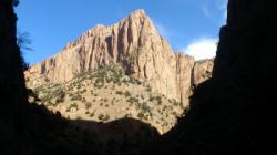
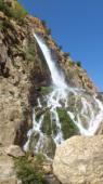
Les Gorges de Taghia

Interesting rock climbing area for routes from 7a to 7c (french grades).
Best time(s) :
- January
- February
- March
- April
- May
- June
- July
- August
- Sept.
- Oct.
- Nov.
- Dec.
Aspect(s) : All Altitude : 2250 m
Approach between 15 min and 2h30 min up hill. Kids friendly ? foot of the crag dangerous for young kids.
Informations :
More than 100 routes, from 6a to 8a , spread over many crags Bolting : traditionnal climbing, sport climbing
Max Height : 800 m.
Rock :
limestone. Characteristic(s) : slab  , vertical
  . Type(s) of holds : crimps, cracks.
Locations :
Area :
Morocco, Tadla-Azilal (تادلة أزيلال), Province d'Azilal, Zaouïa, Taghia.
|
|
Latitude : 31° 46' 52" N | Longitude : 6° 4' 9" W | Sexagesimal & Orientation |
| More coordinates |
VIDEOS
Area added by CA


