Pic du Midi d'Ossau
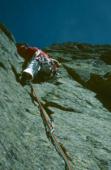
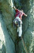
Interesting rock climbing area for routes from 7a to 7c and starting from 8a (french grades).
![Information](/images/attention.png)
Many additional skills about progressing, belaying, escaping technics ... are necessary for multipitch routes security.
Best time(s) : - January
- February
- March
- April
- May
- June
- July
- August
- Sept.
- Oct.
- Nov.
- Dec.
Aspect(s) : All Altitude : 2600 m
Approach 2 heures min steep up hill. Kids friendly ? foot of the crag dangerous for young kids.
Informations :
Between 50 and 100 routes, from 4c to 7b , spread over many crags Bolting : traditionnal climbing, sport climbing
Max Height : 850 m.
Rock :
andésite.
Characteristic(s) : vertical
![Vertical](/images/vertical.png)
, dihedral
![Dièdre](/images/diedre.png)
.
Type(s) of holds : cracks, crimps, slopers.
Locations :
Area :
France, Nouvelle-Aquitaine, Pyrénées-Atlantiques (64), Oloron-Sainte-Marie, Gabas.
![Information](/images/readme.png)
1. Zoom in to get all the rock climbing places 200 km around.
![](/images/mm_20_green.png)
: Bouldering
![](/images/mm_20_orange.png)
: Single pitch
![](/images/mm_20_red.png)
: Multi pitches
![](/images/mm_20_blue.png)
: Deep water soloing
![](/images/mm_20_white.png)
: Differents kind of climbing
Rock climbing area GPS Coordinates : |
Latitude : 42° 50' 26" N |
Longitude : 0° 25' 59" W |
Sexagesimal & Orientation
|
|
Latitude : 42° 50' 26" |
Longitude : -0° 25' 59" |
Degrees, Minutes, Seconds (DMS)
|
|
Latitude : 42° 50.448' |
Longitude : -0° 25.991' |
Degrees, Décimal minutes (DM)
|
|
Latitude : 42.840798° |
Longitude : -0.433187° |
Decimal degrees (DD)
|
|
Parking lot GPS Coordinates : |
Latitude : 42° 48' 55" N |
Longitude : 0° 25' 3" W |
Sexagesimal & Orientation
|
|
Latitude : 42° 48' 55" |
Longitude : -0° 25' 3" |
Degrees, Minutes, Seconds (DMS)
|
|
Latitude : 42° 48.924' |
Longitude : -0° 25.061' |
Degrees, Décimal minutes (DM)
|
|
Latitude : 42.815399° |
Longitude : -0.417684° |
Decimal degrees (DD)
|
Area added by CA