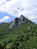
Montselgues
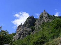
Interesting rock climbing area for routes up to 5c, from 6a to 6c and from 7a to 7c (french grades).
![Information](/images/attention.png)
Many additional skills about progressing, belaying, escaping technics ... are necessary for multipitch routes security.
Best time(s) : - January
- February
- March
- April
- May
- June
- July
- August
- Sept.
- Oct.
- Nov.
- Dec.
Aspect(s) : SW-S-SE Altitude : 800 m
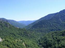
Approach 15 min up hill. Kids friendly ? foot of the crag uneven for young kids.
Informations :
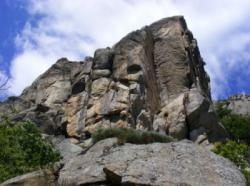
Between 50 and 100 routes, from 4b to 8b. Bolting : big run out climbing
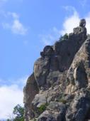
Max Height : 80 m.
Rock :
granite.
Characteristic(s) : slab
![Dalle](/images/dalle.png)
, vertical
![Vertical](/images/vertical.png)
.
Type(s) of holds : cracks, slopers.
Locations :
Area :
France, Auvergne-Rhône-Alpes, Ardèche (07), Les Vans, Les Baumes.
![Information](/images/readme.png)
1. Zoom in to get all the rock climbing places 200 km around.
![](/images/mm_20_green.png)
: Bouldering
![](/images/mm_20_orange.png)
: Single pitch
![](/images/mm_20_red.png)
: Multi pitches
![](/images/mm_20_blue.png)
: Deep water soloing
![](/images/mm_20_white.png)
: Differents kind of climbing
Rock climbing area GPS Coordinates : |
Latitude : 44° 31' 32" N |
Longitude : 3° 58' 49" E |
Sexagesimal & Orientation
|
|
Latitude : 44° 31' 32" |
Longitude : 3° 58' 49" |
Degrees, Minutes, Seconds (DMS)
|
|
Latitude : 44° 31.542' |
Longitude : 3° 58.828' |
Degrees, Décimal minutes (DM)
|
|
Latitude : 44.525701° |
Longitude : 3.980463° |
Decimal degrees (DD)
|
|
Parking lot GPS Coordinates : |
Latitude : 44° 31' 22" N |
Longitude : 3° 58' 52" E |
Sexagesimal & Orientation
|
|
Latitude : 44° 31' 22" |
Longitude : 3° 58' 52" |
Degrees, Minutes, Seconds (DMS)
|
|
Latitude : 44° 31.38' |
Longitude : 3° 58.876' |
Degrees, Décimal minutes (DM)
|
|
Latitude : 44.522999° |
Longitude : 3.98127° |
Decimal degrees (DD)
|
Area added by CA