
")
")


Mancy
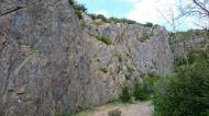
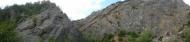
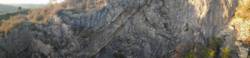
Interesting rock climbing area for routes up to 5c, from 6a to 6c and from 7a to 7c (french grades).
Best time(s) :
- January
- February
- March
- April
- May
- June
- July
- August
- Sept.
- Oct.
- Nov.
- Dec.
Aspect(s) : S Altitude : 400 m
Approach 5 min on flat ground. Kids friendly ? foot of the crag reasonable for young kids.
Informations :
Between 25 and 50 routes, from 3a to 7c. Bolting : sport climbing
Max Height : 20 m.
Rock :
limestone. Characteristic(s) : slab  , vertical
  . Type(s) of holds : underclings, pockets / holes, crimps, cracks.
Réserve Natura 2000, suivre les indications données par le panneau sur le parking.
Locations :
Area :
France, Bourgogne-Franche-Comté, Jura (39), Lons-Le-Saunier, Macornay.
|
|
Latitude : 46° 39' 1" N | Longitude : 5° 32' 50" E | Sexagesimal & Orientation |
|
|
Latitude : 46° 39' 23" N | Longitude : 5° 32' 56" E | Sexagesimal & Orientation |
| More coordinates |
Area added by Thomas


