Les Vuardes
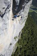
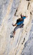
Interesting rock climbing area for routes from 7a to 7c (french grades).
![Information](/images/attention.png)
Many additional skills about progressing, belaying, escaping technics ... are necessary for multipitch routes security.
Best time(s) : - January
- February
- March
- April
- May
- June
- July
- August
- Sept.
- Oct.
- Nov.
- Dec.
Aspect(s) : SE Altitude : 1450 m
Approach between 10 and 45 min rapelling. Kids friendly ? foot of the crag dangerous for young kids.
Informations :
Between 10 and 25 routes, from 6a to 7b. Bolting : traditionnal climbing, sport climbing
Max Height : 200 m.
Rock :
limestone.
Characteristic(s) : slab
![Dalle](/images/dalle.png)
, vertical
![Vertical](/images/vertical.png)
.
Type(s) of holds : crimps, water erosion pockets.
Locations :
Area :
France, Auvergne-Rhône-Alpes, Haute-Savoie (74), Cluses, Romme-sur-Cluses.
![Information](/images/readme.png)
1. Zoom in to get all the rock climbing places 200 km around.
![](/images/mm_20_green.png)
: Bouldering
![](/images/mm_20_orange.png)
: Single pitch
![](/images/mm_20_red.png)
: Multi pitches
![](/images/mm_20_blue.png)
: Deep water soloing
![](/images/mm_20_white.png)
: Differents kind of climbing
Rock climbing area GPS Coordinates : |
Latitude : 46° 1' 16" N |
Longitude : 6° 35' 34" E |
Sexagesimal & Orientation
|
|
Latitude : 46° 1' 16" |
Longitude : 6° 35' 34" |
Degrees, Minutes, Seconds (DMS)
|
|
Latitude : 46° 1.27' |
Longitude : 6° 35.58' |
Degrees, Décimal minutes (DM)
|
|
Latitude : 46.021167° |
Longitude : 6.593° |
Decimal degrees (DD)
|
|
Parking lot GPS Coordinates : |
Latitude : 46° 1' 29" N |
Longitude : 6° 34' 33" E |
Sexagesimal & Orientation
|
|
Latitude : 46° 1' 29" |
Longitude : 6° 34' 33" |
Degrees, Minutes, Seconds (DMS)
|
|
Latitude : 46° 1.488' |
Longitude : 6° 34.563' |
Degrees, Décimal minutes (DM)
|
|
Latitude : 46.024799° |
Longitude : 6.57605° |
Decimal degrees (DD)
|
Area added by Gilles & CA