
")
")


Les rochers de Caudon
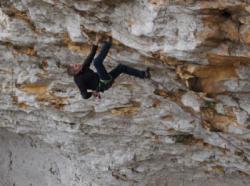

Interesting rock climbing area for routes from 7a to 7c and starting from 8a (french grades).
Best time(s) :
- January
- February
- March
- April
- May
- June
- July
- August
- Sept.
- Oct.
- Nov.
- Dec.
Aspect(s) : NW-N Altitude : 150 m
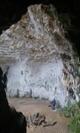
Approach between 5 and 15 min up hill. Kids friendly ? foot of the crag dangerous for young kids.
Informations :
Between 10 and 25 routes, from 6b to 8b , spread over many crags Bolting : sport climbing
Max Height : 60 m.
Rock :
limestone. Characteristic(s) : steep wall  . Type(s) of holds : crimps, slopers.
Further information(s) : Attention aux chutes de pierres possibles.
Locations :
Area :
France, Nouvelle-Aquitaine, Dordogne (24), Périgueux, Cénac-et-Saint-Julien.
|
|
Latitude : 44° 49' 13" N | Longitude : 1° 15' 5" E | Sexagesimal & Orientation |
|
|
Latitude : 44° 49' 16" N | Longitude : 1° 15' 12" E | Sexagesimal & Orientation |
| More coordinates |
Area added by CA


