Les Gorges du Verdon (Les électoraux chocs)
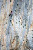
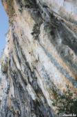
Interesting rock climbing area for routes starting from 8a (french grades).
![Information](/images/attention.png)
Many additional skills about progressing, belaying, escaping technics ... are necessary for multipitch routes security.
Best time(s) : - January
- February
- March
- April
- May
- June
- July
- August
- Sept.
- Oct.
- Nov.
- Dec.
Aspect(s) : N Altitude : 650 m
Approach 30 min steep down hill then steep up hill. Kids friendly ? foot of the crag uneven for young kids.
Informations :
Between 10 and 25 routes, from 7c to 8b. Bolting : sport climbing
Max Height : 180 m.
Rock :
limestone.
Characteristic(s) : steep wall
![Dévers](/images/legerdevers.png)
.
Type(s) of holds : crimps, tufas, ribs.
Further information(s) : 4 routes
Locations :
Area :
France, Provence-Alpes-Côte d'Azur, Var (83), Draguignan, Aiguines.
![Information](/images/readme.png)
1. Zoom in to get all the rock climbing places 200 km around.
![](/images/mm_20_green.png)
: Bouldering
![](/images/mm_20_orange.png)
: Single pitch
![](/images/mm_20_red.png)
: Multi pitches
![](/images/mm_20_blue.png)
: Deep water soloing
![](/images/mm_20_white.png)
: Differents kind of climbing
Rock climbing area GPS Coordinates : |
Latitude : 43° 44' 32" N |
Longitude : 6° 20' 20" E |
Sexagesimal & Orientation
|
|
Latitude : 43° 44' 32" |
Longitude : 6° 20' 20" |
Degrees, Minutes, Seconds (DMS)
|
|
Latitude : 43° 44.536' |
Longitude : 6° 20.338' |
Degrees, Décimal minutes (DM)
|
|
Latitude : 43.742261° |
Longitude : 6.338961° |
Decimal degrees (DD)
|
|
Parking lot GPS Coordinates : |
Latitude : 43° 44' 13" N |
Longitude : 6° 20' 46" E |
Sexagesimal & Orientation
|
|
Latitude : 43° 44' 13" |
Longitude : 6° 20' 46" |
Degrees, Minutes, Seconds (DMS)
|
|
Latitude : 43° 44.232' |
Longitude : 6° 20.777' |
Degrees, Décimal minutes (DM)
|
|
Latitude : 43.737202° |
Longitude : 6.34628° |
Decimal degrees (DD)
|
Area added by CA