
")
")


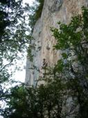
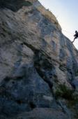
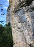
Les Dalles du Marais


Interesting rock climbing area for routes from 6a to 6c, from 7a to 7c and starting from 8a (french grades).
Best time(s) :
- January
- February
- March
- April
- May
- June
- July
- August
- Sept.
- Oct.
- Nov.
- Dec.
Aspect(s) : SE-E Altitude : 750 m
Approach 15 min up hill
Informations :
Between 50 and 100 routes, from 5c to 8b , spread over 3 crags Bolting : sport climbing
Max Height : 80 m.
Rock :
limestone. Characteristic(s) : dihedral  , steep wall
  , vertical
  , slab
  . Type(s) of holds : crimps, cracks.
A sector "biotope" is forbiden from febuary 15 to july 1st.
Locations :
Area :
France, Bourgogne-Franche-Comté, Jura (39), Lons-le-Saunier, Saint-Claude.
|
|
Latitude : 46° 22' 25" N | Longitude : 5° 51' 34" E | Sexagesimal & Orientation |
|
|
Latitude : 46° 22' 16" N | Longitude : 5° 51' 43" E | Sexagesimal & Orientation |
| More coordinates |
Area added by Thomas


