
")
")


Le Cruz
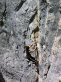
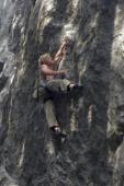
Interesting rock climbing area for routes from 6a to 6c, from 7a to 7c and starting from 8a (french grades).
Best time(s) :
- January
- February
- March
- April
- May
- June
- July
- August
- Sept.
- Oct.
- Nov.
- Dec.
Aspect(s) : SW Altitude : 700 m
Approach 15 min up hill
Informations :
Between 50 and 100 routes, from 4a to 8a , spread over 3 crags Bolting : sport climbing
Max Height : 32 m.
Rock :
limestone. Characteristic(s) : vertical  . Type(s) of holds : crimps, slopers.
We liked this/these route(s) : Oncle Phil
Legendary route(s) : La fessée à clous
Park your car where the dirt road start. Don't go down to the bridge by car.
Web site(s) :
http://www.escalade-74.com/
Locations :
Area :
France, Auvergne-Rhône-Alpes, Haute-Savoie (74), Cluses, Saint-Jeoire.
|
|
Latitude : 46° 9' 18" N | Longitude : 6° 28' 43" E | Sexagesimal & Orientation |
|
|
Latitude : 46° 8' 59" N | Longitude : 6° 28' 14" E | Sexagesimal & Orientation |
| More coordinates |
Area added by Bernard74


