
")
")


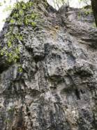
Le bois de l'enfer
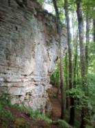

Interesting rock climbing area for routes up to 5c and from 6a to 6c (french grades).
Best time(s) :
- January
- February
- March
- April
- May
- June
- July
- August
- Sept.
- Oct.
- Nov.
- Dec.
Aspect(s) : SW-S Altitude : 300 m
Approach 5 min down hill. Kids friendly ? foot of the crag reasonable for young kids.
Informations :
Between 50 and 100 routes, from 3a to 7b , spread over 2 crags Bolting : sport climbing
Max Height : 25 m.
Rock :
limestone. Characteristic(s) : vertical  , steep wall
  , overhang
  . Type(s) of holds : cracks, crimps.
Web site(s) :
http://olivier.humbert1.free.fr/escalade/rebeuville.html
Locations :
Area :
France, Grand Est, Vosges (88), Neufchateau, Reubeuville.
|
|
Latitude : 48° 19' 33" N | Longitude : 5° 42' 51" E | Sexagesimal & Orientation |
|
|
Latitude : 48° 19' 38" N | Longitude : 5° 42' 50" E | Sexagesimal & Orientation |
| More coordinates |
Area added by Maxime

