
")
")


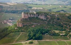
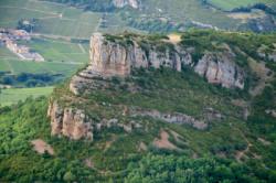
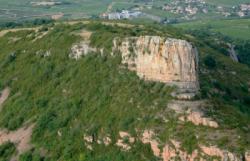
La Roche de Solutré
Interesting rock climbing area for routes up to 5c and from 6a to 6c (french grades).
Best time(s) :
- January
- February
- March
- April
- May
- June
- July
- August
- Sept.
- Oct.
- Nov.
- Dec.
Aspect(s) : SW-S-SE Altitude : 400 m
Approach 10 min up hill. Kids friendly ? foot of the crag uneven for young kids.
Informations :
Between 25 and 50 routes, from 3a to 7b. Bolting : sport climbing
Max Height : 25 m.
Rock :
limestone. Characteristic(s) : vertical  . Type(s) of holds : crimps, slopers.
Further information(s) : Ce site a été médiatisé à partir des années 1980 avec l’ascension rituelle du président François Mitterrand.
Locations :
Area :
France, Bourgogne-Franche-Comté, Saône-et-Loire (71), Mâcon, Solutré-Pouilly.
|
|
Latitude : 46° 17' 54" N | Longitude : 4° 43' 5" E | Sexagesimal & Orientation |
|
|
Latitude : 46° 17' 49" N | Longitude : 4° 43' 5" E | Sexagesimal & Orientation |
| More coordinates |
Area added by CA

