
")
")


L'M
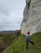
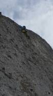
Interesting rock climbing area for routes up to 5c and from 6a to 6c (french grades).
Best time(s) :
- January
- February
- March
- April
- May
- June
- July
- August
- Sept.
- Oct.
- Nov.
- Dec.
Aspect(s) : W Altitude : 50 m
Approach . Kids friendly ? foot of the crag comfortable for young kids.
Informations :
Between 25 and 50 routes, from 4a to 6c. Bolting : traditionnal climbing
Max Height : 40 m.
Rock :
limestone. Characteristic(s) : vertical  . Type(s) of holds : crimps, cracks.
Locations :
Area :
France, Normandie, Eure (27), Rouen, Poses, Connelles.
|
|
Latitude : 49° 16' 56" N | Longitude : 1° 16' 16" E | Sexagesimal & Orientation |
|
|
Latitude : 49° 16' 40" N | Longitude : 1° 16' 16" E | Sexagesimal & Orientation |
| More coordinates |
Area added by someone who did not leave her/his name :)


