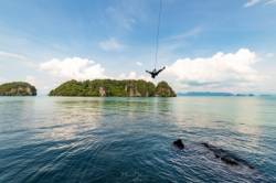
Ko Yao Noi
Interesting rock climbing area for routes from 6a to 6c and from 7a to 7c (french grades).
![Information](/images/attention.png)
Many additional skills about progressing, belaying, escaping technics ... are necessary for multipitch routes security.
Best time(s) : - January
- February
- March
- April
- May
- June
- July
- August
- Sept.
- Oct.
- Nov.
- Dec.
Aspect(s) : All Altitude : 50 m
Approach 40 min by boat. Kids friendly ? foot of the crag dangerous for young kids.
Informations :
More than 100 routes, from 5c to 8a , spread over many crags Bolting : sport climbing
Max Height : 30 m.
Rock :
limestone.
Characteristic(s) : steep wall
![Dévers](/images/legerdevers.png)
, vertical
![Vertical](/images/vertical.png)
, slab
![Dalle](/images/dalle.png)
.
Type(s) of holds : crimps, tufas, ribs.
Locations :
Area :
Thailand, Krabi Province (กระบี่), Amphur Ao Luek, Ao Nang, Baan Tha Khao.
![Information](/images/readme.png)
1. Zoom in to get all the rock climbing places 200 km around.
![](/images/mm_20_green.png)
: Bouldering
![](/images/mm_20_orange.png)
: Single pitch
![](/images/mm_20_red.png)
: Multi pitches
![](/images/mm_20_blue.png)
: Deep water soloing
![](/images/mm_20_white.png)
: Differents kind of climbing
Rock climbing area GPS Coordinates : |
Latitude : 8° 10' 42" N |
Longitude : 98° 38' 9" E |
Sexagesimal & Orientation
|
|
Latitude : 8° 10' 42" |
Longitude : 98° 38' 9" |
Degrees, Minutes, Seconds (DMS)
|
|
Latitude : 8° 10.707' |
Longitude : 98° 38.16' |
Degrees, Décimal minutes (DM)
|
|
Latitude : 8.178447° |
Longitude : 98.635996° |
Decimal degrees (DD)
|
|
Parking lot GPS Coordinates : |
Latitude : 8° 8' 39" N |
Longitude : 98° 44' 45" E |
Sexagesimal & Orientation
|
|
Latitude : 8° 8' 39" |
Longitude : 98° 44' 45" |
Degrees, Minutes, Seconds (DMS)
|
|
Latitude : 8° 8.653' |
Longitude : 98° 44.753' |
Degrees, Décimal minutes (DM)
|
|
Latitude : 8.144214° |
Longitude : 98.745887° |
Decimal degrees (DD)
|
Area added by CA