")
")


Hauteroche
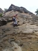

Interesting rock climbing area for routes up to 5c and from 6a to 6c (french grades).
Best time(s) :
- January
- February
- March
- April
- May
- June
- July
- August
- Sept.
- Oct.
- Nov.
- Dec.
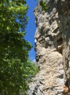
Aspect(s) : W-SW-S Altitude : 450 m
Approach between 15 and 20 min . Kids friendly ? foot of the crag reasonable for young kids.
Informations :
More than 200 routes, from 3a to 8a. Bolting : sport climbing
Max Height : 30 m.
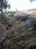
Rock :
limestone. Characteristic(s) : vertical  , slab
  . Type(s) of holds : crimps.
Further information(s) : Rockfall, helmet compulsory.
Part of the site's routes are closed from February 15 to June 15 to allow birds to reproduce.
Part of the site's routes are closed from February 15 to June 15 to allow birds to reproduce.
Locations :
Area :
France, Bourgogne-Franche-Comté, Côte-d'Or (21), Vitteaux, Hauteroche.
|
|
Latitude : 47° 28' 43" N | Longitude : 4° 36' 20" E | Sexagesimal & Orientation |
|
|
Latitude : 47° 29' 10" N | Longitude : 4° 35' 36" E | Sexagesimal & Orientation |
| More coordinates |
Area added by CA