")
")


Frankenjura (Leupoldsteiner Wand)
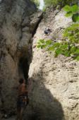
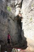
Interesting rock climbing area for routes up to 5c, from 6a to 6c, from 7a to 7c and starting from 8a (french grades).
Best time(s) :
- January
- February
- March
- April
- May
- June
- July
- August
- Sept.
- Oct.
- Nov.
- Dec.
Aspect(s) : All Altitude : 550 m
Approach 2 min on flat ground. Kids friendly ? foot of the crag comfortable for young kids.
Informations :
Between 50 and 100 routes, from 3 to 10- , spread over many crags Bolting : sport climbing
Max Height : 20 m.
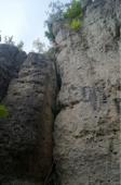
Rock :
limestone. Characteristic(s) : vertical  . Type(s) of holds : pockets / holes, crimps.
We liked this/these route(s) : Master of Desaster 8a+
Locations :
Area :
Germany, Bayern, Regierungsbezirk Oberfranken, Forchheim, Leupoltstein.
|
|
Latitude : 49° 41' 35" N | Longitude : 11° 23' 23" E | Sexagesimal & Orientation |
|
|
Latitude : 49° 41' 38" N | Longitude : 11° 23' 22" E | Sexagesimal & Orientation |
| More coordinates |
Area added by Jannis F.