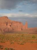
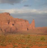
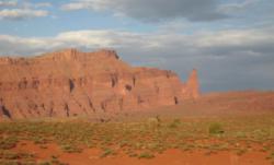
Fisher Towers
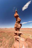
Interesting rock climbing area for routes from 7a to 7c (french grades).
![Information](/images/attention.png)
Many additional skills about progressing, belaying, escaping technics ... are necessary for multipitch routes security.
Best time(s) : - January
- February
- March
- April
- May
- June
- July
- August
- Sept.
- Oct.
- Nov.
- Dec.
Aspect(s) : All Altitude : 1500 m
Approach steep up hill. Kids friendly ? foot of the crag dangerous for young kids.
Informations :
Between 10 and 25 routes, from 5.8 to 5.12b , spread over many crags Bolting : traditionnal climbing, sport climbing
Max Height : 300 m.
Rock :
sandstone.
Characteristic(s) : vertical
![Vertical](/images/vertical.png)
.
Type(s) of holds : crimps, slopers.
Further information(s) : Magnifique vu d'en bas mais le rocher est péteux ou poussiéreux. Certaines voies se passent en artif.
Locations :
Area :
United States, Utah, Grand County, Moab.
![Information](/images/readme.png)
1. Zoom in to get all the rock climbing places 200 km around.
![](/images/mm_20_green.png)
: Bouldering
![](/images/mm_20_orange.png)
: Single pitch
![](/images/mm_20_red.png)
: Multi pitches
![](/images/mm_20_blue.png)
: Deep water soloing
![](/images/mm_20_white.png)
: Differents kind of climbing
Rock climbing area GPS Coordinates : |
Latitude : 38° 43' 21" N |
Longitude : 109° 18' 9" W |
Sexagesimal & Orientation
|
|
Latitude : 38° 43' 21" |
Longitude : -109° 18' 9" |
Degrees, Minutes, Seconds (DMS)
|
|
Latitude : 38° 43.365' |
Longitude : -109° 18.163' |
Degrees, Décimal minutes (DM)
|
|
Latitude : 38.722754° |
Longitude : -109.302721° |
Decimal degrees (DD)
|
|
Parking lot GPS Coordinates : |
Latitude : 38° 43' 29" N |
Longitude : 109° 18' 32" W |
Sexagesimal & Orientation
|
|
Latitude : 38° 43' 29" |
Longitude : -109° 18' 32" |
Degrees, Minutes, Seconds (DMS)
|
|
Latitude : 38° 43.494' |
Longitude : -109° 18.54' |
Degrees, Décimal minutes (DM)
|
|
Latitude : 38.724899° |
Longitude : -109.308998° |
Decimal degrees (DD)
|
VIDEOS
Area added by CA