")
")


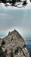
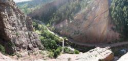
Eldorado Canyon

bouldering, single pitch routes and multi pitch routes rock climbing area
Best time(s) :
- January
- February
- March
- April
- May
- June
- July
- August
- Sept.
- Oct.
- Nov.
- Dec.
Aspect(s) : All Altitude : 1800 m
Approach between 5 and 15 min up hill
Rock :
sandstone. Characteristic(s) : dihedral  , steep wall
  , vertical
  , slab
  . Type(s) of holds : crimps, cracks, slopers.
Informations :
Bouldering
Interesting bouldering area for problems from 7a to 7c and starting from 8a (Fontainebleau grades).
More than 100 problems, from V0 to V16, spread over many areas.
Kids friendly ? area around the boulders uneven for young kids.
Landing quality : flat ground (1 crash pad needed) or uneven or steep ground (1 crash pad and 1 spotter needed) or chaotic ground (many crash pads and numerous spotters needed).
Single pitch routes
Interesting rock climbing area for routes from 6a to 6c and from 7a to 7c (french grades).
More than 500 routes, from 5.3 to 5.13a, spread over many crags. Bolting : traditionnal climbing, big run out climbing.
Kids friendly ? foot of the crag dangerous for young kids.
Multi pitch routes
Interesting rock climbing area for routes from 6a to 6c (french grades).
More than 400 routes, from 5.5 to 5.12a, spread over many crags. Bolting : traditionnal climbing.
Kids friendly ? foot of the crag dangerous for young kids.
Legendary problem(s) :
Megatron V17 first ascent by Shawn Raboutou on april 2022. Firsts repeats : Hamish McArthur (2025), Zach Galla (2026)
Locations :
Area :
United States, Colorado, Boulder County, Denver, Eldorado Springs.
|
|
Latitude : 39° 55' 50" N | Longitude : 105° 16' 58" W | Sexagesimal & Orientation |
|
|
Latitude : 39° 55' 53" N | Longitude : 105° 16' 51" W | Sexagesimal & Orientation |
| More coordinates |
VIDEOS
Area added by CA