")
")


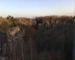
Eifel (Ettringer Lay)


Interesting rock climbing area for routes from 6a to 6c and from 7a to 7c (french grades).
Best time(s) :
- January
- February
- March
- April
- May
- June
- July
- August
- Sept.
- Oct.
- Nov.
- Dec.
Aspect(s) : All Altitude : 350 m
Approach 10 min easy down hill. Kids friendly ? foot of the crag uneven for young kids.
Informations :
Between 50 and 100 routes, from 3a to 8b and some projects , spread over many crags Bolting : sport climbing
Max Height : 30 m. Average Height : 20 m.
Rock :
basalt. Characteristic(s) : steep wall  , vertical
  , slab
  . Type(s) of holds : crimps, cracks, slopers.
Further information(s) : Große Wand und Kühlschrank, es gibt viele weitere Bereiche die man klettern kann!
Locations :
Area :
Germany, Rheinland-Pfalz, North, Koblenz, Ettringen.
|
|
Latitude : 50° 20' 44" N | Longitude : 7° 13' 25" E | Sexagesimal & Orientation |
|
|
Latitude : 50° 20' 49" N | Longitude : 7° 13' 22" E | Sexagesimal & Orientation |
| More coordinates |
Area added by Charly