")
")


Clécy (L'aiguillette du Pain de Sucre)
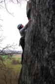
Interesting rock climbing area for routes up to 5c (french grades).
Best time(s) :
- January
- February
- March
- April
- May
- June
- July
- August
- Sept.
- Oct.
- Nov.
- Dec.
Aspect(s) : S Altitude : 50 m
Approach
Informations :
Between 10 and 25 routes, from 3a to 7a. Bolting : traditionnal climbing, sport climbing
Max Height : 100 m.
Rock :
conglomerate. Characteristic(s) : dihedral  , slab
  . Type(s) of holds : cracks.
Locations :
Area :
France, Normandie, Calvados (14), Caen, Clécy.
|
|
Latitude : 48° 55' 42" N | Longitude : 0° 28' 26" W | Sexagesimal & Orientation |
|
|
Latitude : 48° 55' 39" N | Longitude : 0° 28' 49" W | Sexagesimal & Orientation |
| More coordinates |
Area added by someone who did not leave her/his name :)