
")
")


Calamancina
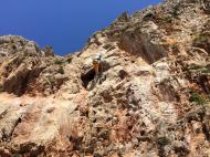


Interesting rock climbing area for routes up to 5c, from 6a to 6c and from 7a to 7c (french grades).
Best time(s) :
- January
- February
- March
- April
- May
- June
- July
- August
- Sept.
- Oct.
- Nov.
- Dec.
Aspect(s) : W Altitude : 24 m
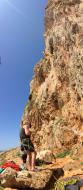
Approach 5 min easy up hill. Kids friendly ? foot of the crag reasonable for young kids.
Informations :
Between 50 and 100 routes, from 4a to 8a , spread over many crags Bolting : sport climbing
Max Height : 30 m.
Rock :
limestone. Characteristic(s) : slab  , vertical
  , steep wall
  , overhang
  . Type(s) of holds : side pulls, underclings, jugs, pockets / holes, crimps, water erosion pockets, pebbles, cracks, tufas, ribs, slopers.
Locations :
Area :
Italy, Sicilia, Provincia di Trapani, Trapani, San Vito Lo Capo.
|
|
Latitude : 38° 10' 31" N | Longitude : 12° 43' 1" E | Sexagesimal & Orientation |
|
|
Latitude : 38° 10' 38" N | Longitude : 12° 43' 0" E | Sexagesimal & Orientation |
| More coordinates |
Area added by Ruggero


