
")
")


Barton Creek Greenbelt
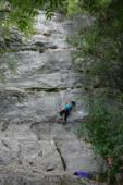
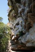
Interesting rock climbing area for routes up to 5c, from 6a to 6c and from 7a to 7c (french grades).
Best time(s) :
- January
- February
- March
- April
- May
- June
- July
- August
- Sept.
- Oct.
- Nov.
- Dec.
Aspect(s) : W-S-E Altitude : 150 m
Approach 3 min easy down hill. Kids friendly ? foot of the crag comfortable for young kids.
Informations :
More than 100 routes, from 5.6 to 5.13b , spread over 15 crags Bolting : sport climbing
Max Height : 25 m.
Rock :
limestone. Characteristic(s) : slab  , vertical
  , steep wall
  , overhang
  . Type(s) of holds : side pulls, underclings, jugs, pockets / holes, crimps, water erosion pockets, cracks, slopers.
We liked this/these route(s) : Seismic's routes are for the most part good even quality. Gus Fruh's routes are cryptic/interesting/hard to read. New Wall / Great Wall are a little more straight forward, taller.
Legendary route(s) : Hysteria ; Diving for Rocks ; Iron Man ; Through the Looking Glass ; Tunnel Vision ; Peewee's Big Adventure
Further information(s) : Austin is a fun climbing destination because the routes are so sustained, and so convenient. This Greenbelt area is right down town, so you can hit the west-of-town areas (Reimers, Monster Rock, Pace Bend's DWS) 35-minutes away, then hit the Greenbelt for semi-rest days with less drive time. If you are traveling alone, the Greenbelt is a great place to meet up, as is Reimers' prototype wall on Saturday/Sunday. The crag location and parking entered for this area is just for Seismic Wall. Look on-line or order the guidebook for all the other Greenbelt crags.
No smoking in the city parks. Dogs on leash.
Due to fires and large crack formations main wall is closed.
Due to fires and large crack formations main wall is closed.
Locations :
Area :
United States, Texas, Travis County, Austin.
|
|
Latitude : 30° 14' 43" N | Longitude : 97° 48' 1" W | Sexagesimal & Orientation |
|
|
Latitude : 30° 14' 36" N | Longitude : 97° 48' 2" W | Sexagesimal & Orientation |
| More coordinates |
Area added by John Hogge


