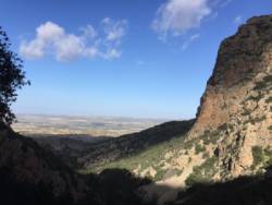
Zaghouan
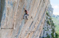
Interesting rock climbing area for routes up to 5c, from 6a to 6c and from 7a to 7c (french grades).
![Information](/images/attention.png)
Many additional skills about progressing, belaying, escaping technics ... are necessary for multipitch routes security.
Best time(s) : - January
- February
- March
- April
- May
- June
- July
- August
- Sept.
- Oct.
- Nov.
- Dec.
Altitude : 500 m
Approach between 10 and 20 min up hill. Kids friendly ? foot of the crag uneven for young kids.
Informations :
Between 25 and 50 routes, from 4a to 8a , spread over many crags Bolting : sport climbing
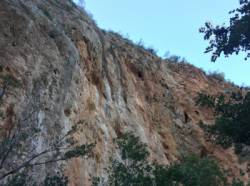
Max Height : 150 m.
Rock :
limestone.
Characteristic(s) : vertical
![Vertical](/images/vertical.png)
, steep wall
![Dévers](/images/legerdevers.png)
.
Type(s) of holds : tufas, ribs.
Further information(s) : http://www.speleo-tunisie.com/escalade/english/index.html
Locations :
Area :
Tunisia, Gouvernorat de Zaghouan (ولاية زغوان), Zaghouan delegation, Tunis, Zaghouan.
![Information](/images/readme.png)
1. Zoom in to get all the rock climbing places 200 km around.
![](/images/mm_20_green.png)
: Bouldering
![](/images/mm_20_orange.png)
: Single pitch
![](/images/mm_20_red.png)
: Multi pitches
![](/images/mm_20_blue.png)
: Deep water soloing
![](/images/mm_20_white.png)
: Differents kind of climbing
Rock climbing area GPS Coordinates : |
Latitude : 36° 22' 44" N |
Longitude : 10° 7' 4" E |
Sexagesimal & Orientation
|
|
Latitude : 36° 22' 44" |
Longitude : 10° 7' 4" |
Degrees, Minutes, Seconds (DMS)
|
|
Latitude : 36° 22.742' |
Longitude : 10° 7.067' |
Degrees, Décimal minutes (DM)
|
|
Latitude : 36.379037° |
Longitude : 10.117781° |
Decimal degrees (DD)
|
|
Parking lot GPS Coordinates : |
Latitude : 36° 22' 55" N |
Longitude : 10° 6' 48" E |
Sexagesimal & Orientation
|
|
Latitude : 36° 22' 55" |
Longitude : 10° 6' 48" |
Degrees, Minutes, Seconds (DMS)
|
|
Latitude : 36° 22.926' |
Longitude : 10° 6.804' |
Degrees, Décimal minutes (DM)
|
|
Latitude : 36.382099° |
Longitude : 10.1134° |
Decimal degrees (DD)
|
Area added by CA