
")
")


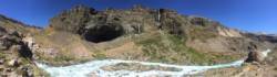
Valle de los Cóndores


Interesting rock climbing area for routes up to 5c, from 6a to 6c, from 7a to 7c and starting from 8a (french grades).
Best time(s) :
- January
- February
- March
- April
- May
- June
- July
- August
- Sept.
- Oct.
- Nov.
- Dec.
Aspect(s) : NW-N Altitude : 1950 m
Approach 5 min down hill then up hill. Kids friendly ? foot of the crag uneven for young kids.
Informations :
Between 50 and 100 routes, from 5.7 to 5.14b , spread over many crags Bolting : sport climbing
Max Height : 30 m.
Rock :
basalt. Characteristic(s) : dihedral  , vertical
  , slab
  . Type(s) of holds : side pulls, underclings, jugs, crimps, cracks, slopers.
Legendary route(s) : Pasito a Pasito 9a (F.A. Alex Megos march 2017)
Locations :
Area :
Chile, VII Región del Maule, Provincia de Talca, San Clemente, La Mina.
|
|
Latitude : 35° 58' 8" S | Longitude : 70° 33' 56" W | Sexagesimal & Orientation |
|
|
Latitude : 35° 58' 9" S | Longitude : 70° 34' 9" W | Sexagesimal & Orientation |
| More coordinates |
VIDEOS
Area added by Victor castro

