
")
")


- United States
Urduliz
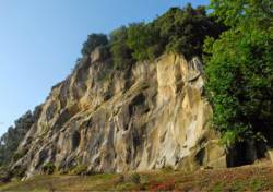
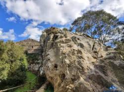
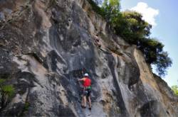
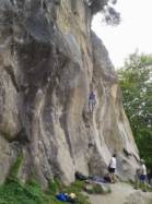


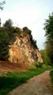
Interesting rock climbing area for routes up to 5c, from 6a to 6c and from 7a to 7c (french grades).
Best time(s) :
- January
- February
- March
- April
- May
- June
- July
- August
- Sept.
- Oct.
- Nov.
- Dec.
Aspect(s) : SW-NE Altitude : 150 m
Approach 5 min easy up hill. Kids friendly ? foot of the crag comfortable for young kids.
Informations :
Between 50 and 100 routes, from 3a to 8a , spread over many crags Bolting : sport climbing
Max Height : 40 m.
Rock :
schist, sandstone (armorican). Characteristic(s) : slab  , vertical
  , steep wall
  , overhang
  , dihedral
  . Type(s) of holds : jugs, pockets / holes, crimps, cracks, slopers.
Locations :
Area :
Spain, País Vasco (Euskadi), Provincia de Vizcaya (Bizkaia), Bilbao, Urduliz.
|
|
Latitude : 43° 22' 19" N | Longitude : 2° 57' 35" W | Sexagesimal & Orientation |
|
|
Latitude : 43° 22' 21" N | Longitude : 2° 57' 37" W | Sexagesimal & Orientation |
| More coordinates |
Area added by someone who did not leave her/his name :)


