Trident du Tacul
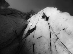
Interesting rock climbing area for routes from 6a to 6c, from 7a to 7c and starting from 8a (french grades).
![Information](/images/attention.png)
Many additional skills about progressing, belaying, escaping technics ... are necessary for multipitch routes security.
Best time(s) : - January
- February
- March
- April
- May
- June
- July
- August
- Sept.
- Oct.
- Nov.
- Dec.
Aspect(s) : SW-S-SE Altitude : 3400 m
Approach Depuis le téléphérique de l'aiguille du Midi: 180 min steep up hill. Kids friendly ? foot of the crag dangerous for young kids.
Informations :
Less than 10 routes, from 5c to 7c. Bolting : traditionnal climbing
Max Height : 550 m.
Rock :
granite.
Characteristic(s) : dihedral
![Dièdre](/images/diedre.png)
, vertical
![Vertical](/images/vertical.png)
.
Type(s) of holds : cracks.
Escalade de style alpin: Bonne météo obligatoire.
Locations :
Area :
France, Auvergne-Rhône-Alpes, Haute-Savoie (74), Annecy, Chamonix-Mont-Blanc.
![Information](/images/readme.png)
1. Zoom in to get all the rock climbing places 200 km around.
![](/images/mm_20_green.png)
: Bouldering
![](/images/mm_20_orange.png)
: Single pitch
![](/images/mm_20_red.png)
: Multi pitches
![](/images/mm_20_blue.png)
: Deep water soloing
![](/images/mm_20_white.png)
: Differents kind of climbing
Rock climbing area GPS Coordinates : |
Latitude : 45° 51' 2" N |
Longitude : 6° 54' 0" E |
Sexagesimal & Orientation
|
|
Latitude : 45° 51' 2" |
Longitude : 6° 54' 0" |
Degrees, Minutes, Seconds (DMS)
|
|
Latitude : 45° 51.036' |
Longitude : 6° 54.014' |
Degrees, Décimal minutes (DM)
|
|
Latitude : 45.850603° |
Longitude : 6.900232° |
Decimal degrees (DD)
|
|
Parking lot GPS Coordinates : |
Latitude : 45° 55' 1" N |
Longitude : 6° 52' 14" E |
Sexagesimal & Orientation
|
|
Latitude : 45° 55' 1" |
Longitude : 6° 52' 14" |
Degrees, Minutes, Seconds (DMS)
|
|
Latitude : 45° 55.019' |
Longitude : 6° 52.249' |
Degrees, Décimal minutes (DM)
|
|
Latitude : 45.916981° |
Longitude : 6.870814° |
Decimal degrees (DD)
|
Area added by CA