
")
")


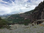
Telluride (The Pipeline Wall)
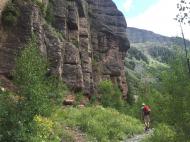
Interesting rock climbing area for routes up to 5c and from 6a to 6c (french grades).
Best time(s) :
- January
- February
- March
- April
- May
- June
- July
- August
- Sept.
- Oct.
- Nov.
- Dec.
Aspect(s) : SW Altitude : 3000 m
Approach 15 min on flat ground. Kids friendly ? foot of the crag reasonable for young kids.
Informations :
Between 10 and 25 routes, from 5.7 to 5.11c. Bolting : sport climbing
Max Height : 80 m. Average Height : 30 m.
Rock :
conglomerate. Characteristic(s) : vertical  . Type(s) of holds : crimps, cracks.
Further information(s) : 4 wheels drive access or walk from the main parking below.
Locations :
Area :
United States, Colorado, San Miguel County, Durango, Telluride.
|
|
Latitude : 37° 55' 35" N | Longitude : 107° 46' 8" W | Sexagesimal & Orientation |
|
|
Latitude : 37° 55' 20" N | Longitude : 107° 46' 0" W | Sexagesimal & Orientation |
| More coordinates |
Area added by King wah, vavoum


