
")
")


Tautavel (Saint-Martin)

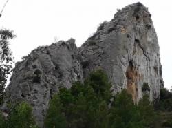
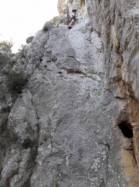
Interesting rock climbing area for routes up to 5c, from 6a to 6c and from 7a to 7c (french grades).
Best time(s) :
- January
- February
- March
- April
- May
- June
- July
- August
- Sept.
- Oct.
- Nov.
- Dec.
Aspect(s) : NE-N Altitude : 150 m
Approach 10 min up hill. Kids friendly ? foot of the crag uneven for young kids.
Informations :
Between 25 and 50 routes, from 3a to 7c , spread over 2 crags Bolting : sport climbing
Max Height : 40 m.
Rock :
limestone. Characteristic(s) : steep wall  , vertical
  . Type(s) of holds : crimps.
We liked this/these route(s) : La Bonnelli 6a
Further information(s) : De Tautavel, emprunter la D9 en direction d’Estagel. Traverser le pont et ne pas manquer le premier embranchement à gauche direction camping «Le Priourat». Après les habitations, à la fourche, prendre la piste en terre de gauche. Le par-king se situe sur la droite après 200 m en bordure de vignes (petit parking GPS 42.8104, 2.7424). En traversant le Verdouble à gué, lorsque celui-ci est à l’étiage, un accès plus rapide existe depuis le parking du secteur le Château.
Il y a aussi un petit secteur d'initiation avec 6 voies en face Sus-Ouest plus à gauche.
Il y a aussi un petit secteur d'initiation avec 6 voies en face Sus-Ouest plus à gauche.
Locations :
Area :
France, Occitanie, Pyrénées-Orientales (66), Perpignan, Tautavel.
|
|
Latitude : 42° 48' 33" N | Longitude : 2° 44' 34" E | Sexagesimal & Orientation |
|
|
Latitude : 42° 48' 41" N | Longitude : 2° 44' 25" E | Sexagesimal & Orientation |
| More coordinates |
Area added by CA


