
")
")


Steele


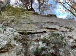

Interesting rock climbing area for routes from 6a to 6c and from 7a to 7c (french grades).
Best time(s) :
- January
- February
- March
- April
- May
- June
- July
- August
- Sept.
- Oct.
- Nov.
- Dec.
Aspect(s) : SE Altitude : 350 m
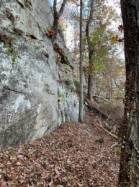
Approach between 15 and 30 min up hill. Kids friendly ? foot of the crag reasonable for young kids.
Informations :
More than 100 routes, from 5.7 to 5.13a , spread over many crags Bolting : traditionnal climbing, sport climbing
Max Height : 40 m.
Rock :
sandstone. Characteristic(s) : vertical  , overhang
  . Type(s) of holds : crimps, cracks, slopers.
Locations :
Area :
United States, Alabama, Saint Clair County, Gadsden, Steele.
|
|
Latitude : 33° 56' 8" N | Longitude : 86° 14' 8" W | Sexagesimal & Orientation |
|
|
Latitude : 33° 56' 3" N | Longitude : 86° 13' 59" W | Sexagesimal & Orientation |
| More coordinates |
Area added by CA

