")
")


Schriesheim Steinbruch
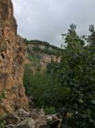
Interesting rock climbing area for routes up to 5c, from 6a to 6c, from 7a to 7c and starting from 8a (french grades).
Best time(s) :
- January
- February
- March
- April
- May
- June
- July
- August
- Sept.
- Oct.
- Nov.
- Dec.
Aspect(s) : SW Altitude : 400 m
Approach 30 min up hill. Kids friendly ? foot of the crag dangerous for young kids.
Informations :
More than 200 routes, from III to X , spread over many crags Bolting : sport climbing
Max Height : 35 m.
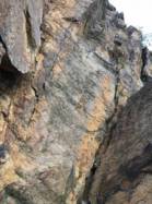
Rock :
porphyre. Characteristic(s) : slab  , vertical
  , overhang
  , dihedral
  . Type(s) of holds : side pulls, underclings, jugs, pockets / holes, crimps, cracks.
Naturschutzgebiet.
Helm mitbringen!
Helm mitbringen!
Locations :
Area :
Germany, Baden-Württemberg, Landkreis Karlsruhe, Heidelberg, Schriesheim.
|
|
Latitude : 49° 28' 8" N | Longitude : 8° 40' 46" E | Sexagesimal & Orientation |
|
|
Latitude : 49° 28' 34" N | Longitude : 8° 39' 44" E | Sexagesimal & Orientation |
| More coordinates |
Area added by someone who did not leave her/his name :)