
")
")


Saint-Moirans

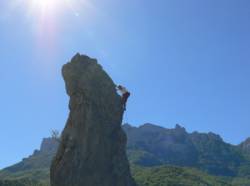
Interesting rock climbing area for routes up to 5c, from 6a to 6c and from 7a to 7c (french grades).
Best time(s) :
- January
- February
- March
- April
- May
- June
- July
- August
- Sept.
- Oct.
- Nov.
- Dec.
Aspect(s) : S-SE Altitude : 500 m
Approach between 2 and 10 min up hill. Kids friendly ? foot of the crag reasonable for young kids.
Informations :
Between 50 and 100 routes, from 3b to 8a , spread over many crags Bolting : sport climbing
Max Height : 80 m.
Rock :
limestone. Characteristic(s) : slab  , vertical
  , steep wall
  , overhang
  , dihedral
  . Type(s) of holds : cracks, side pulls, jugs, crimps, water erosion pockets.
We liked this/these route(s) : Capitaine Fracasse 5b ; Cacapouêt ; la ballade à Jimmy ; Viva Zapata ; A vous! ; Hannah statique ; Archi-guigui ; TotemChoucroute garnie
Further information(s) : "El Topo St Moirans" est disponible à l'office du tourisme de Saillans entre autre au prix de 10€.
Locations :
Area :
France, Auvergne-Rhône-Alpes, Drôme (26), Valence, Chastel-Arnaud.
|
|
Latitude : 44° 39' 59" N | Longitude : 5° 12' 16" E | Sexagesimal & Orientation |
|
|
Latitude : 44° 39' 57" N | Longitude : 5° 12' 21" E | Sexagesimal & Orientation |
| More coordinates |
Area added by Ben

