
")
")


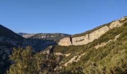
Saint-Cézaire
Interesting rock climbing area for routes from 6a to 6c, from 7a to 7c and starting from 8a (french grades).
Best time(s) :
- January
- February
- March
- April
- May
- June
- July
- August
- Sept.
- Oct.
- Nov.
- Dec.
Aspect(s) : W-S-N Altitude : 350 m
Approach 35 min up hill. Kids friendly ? foot of the crag reasonable for young kids.
Informations :
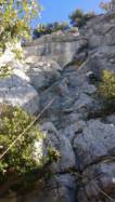
Between 50 and 100 routes, from 5b to 8b , spread over many crags Bolting : big run out climbing
Max Height : 35 m.
Rock :
limestone. Characteristic(s) : vertical  , steep wall
  , dihedral
  . Type(s) of holds : crimps, tufas, ribs.
Secteur Grotte EDF interdit.
Locations :
Area :
France, Provence-Alpes-Côte d'Azur, Alpes-Maritimes (06), Grasse, Saint-Cézaire-sur-Siagne.
|
|
Latitude : 43° 41' 15" N | Longitude : 6° 46' 20" E | Sexagesimal & Orientation |
|
|
Latitude : 43° 40' 16" N | Longitude : 6° 46' 30" E | Sexagesimal & Orientation |
| More coordinates |
VIDEOS
Area added by CA

