
")
")


Ruine Falkenstein (Teufelsküche)
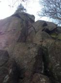
Interesting rock climbing area for routes up to 5c, from 6a to 6c and from 7a to 7c (french grades).
Best time(s) :
- January
- February
- March
- April
- May
- June
- July
- August
- Sept.
- Oct.
- Nov.
- Dec.
Aspect(s) : SW-S-SE-E-NE Altitude : 550 m
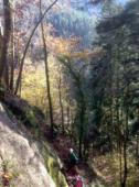
Approach 10 min steep up hill. Kids friendly ? foot of the crag reasonable for young kids.
Informations :
Between 50 and 100 routes, from III to IX , spread over many crags Bolting : sport climbing
Max Height : 30 m.
Rock :
granite. Characteristic(s) : dihedral  , overhang
  , steep wall
  , vertical
  , slab
  . Type(s) of holds : pockets / holes, crimps, cracks, slopers.
Further information(s) : Ausstiegsverbot: Umlenker verwenden
Web site(s) :
http://www.dav-obererneckar.de/index.php?id=259
Locations :
Area :
Germany, Baden-Württemberg, Regierungsbezirk Freiburg, Schramberg, Schramberg.
|
|
Latitude : 48° 12' 46" N | Longitude : 8° 22' 51" E | Sexagesimal & Orientation |
|
|
Latitude : 48° 12' 40" N | Longitude : 8° 22' 50" E | Sexagesimal & Orientation |
| More coordinates |
Area added by Sascha Eggs


