
")
")


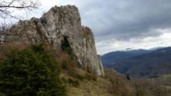
Roquefixade (Roc de Louis)
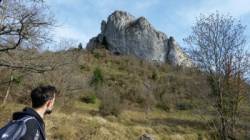
Interesting rock climbing area for routes from 6a to 6c and from 7a to 7c (french grades).
Best time(s) :
- January
- February
- March
- April
- May
- June
- July
- August
- Sept.
- Oct.
- Nov.
- Dec.
Aspect(s) : W-SW Altitude : 800 m
Approach 5 min up hill. Kids friendly ? foot of the crag uneven for young kids.
Informations :
Between 25 and 50 routes, from 4c to 8b. Bolting : sport climbing
Max Height : 20 m.
Rock :
limestone. Characteristic(s) : vertical  . Type(s) of holds : crimps.
Further information(s) :
Web site(s) :
http://cafma.free.fr/roquefixade/fr_secteur.htm
Locations :
Area :
France, Occitanie, Ariège (09), Lavelanet, Roquefixade.
|
|
Latitude : 42° 56' 0" N | Longitude : 1° 46' 1" E | Sexagesimal & Orientation |
|
|
Latitude : 42° 55' 56" N | Longitude : 1° 46' 6" E | Sexagesimal & Orientation |
| More coordinates |
Area added by CA


