")
")


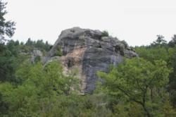
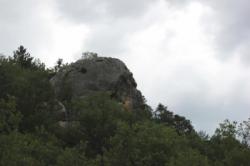
Rocher Saark (Pont de Geydan)
Interesting rock climbing area for routes from 6a to 6c and starting from 8a (french grades).
Best time(s) :
- January
- February
- March
- April
- May
- June
- July
- August
- Sept.
- Oct.
- Nov.
- Dec.
Aspect(s) : W-S Altitude : 550 m
Approach 2 min up hill. Kids friendly ? foot of the crag uneven for young kids.
Informations :
Between 10 and 25 routes, from 5c to 8b. Bolting : sport climbing
Max Height : 20 m.
Rock :
limestone. Characteristic(s) : steep wall  , vertical
  . Type(s) of holds : crimps.
Locations :
Area :
France, Provence-Alpes-Côte d'Azur, Alpes-de-Haute-Provence (04), Digne-les-Bains, Entrevaux.
|
|
Latitude : 43° 58' 3" N | Longitude : 6° 45' 9" E | Sexagesimal & Orientation |
|
|
Latitude : 43° 58' 1" N | Longitude : 6° 45' 10" E | Sexagesimal & Orientation |
| More coordinates |
Area added by CA