
")
")


- United States
Rocher du Mouflon
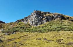

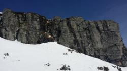

Interesting rock climbing area for routes from 6a to 6c (french grades).
Best time(s) :
- January
- February
- March
- April
- May
- June
- July
- August
- Sept.
- Oct.
- Nov.
- Dec.
Aspect(s) : SW-S Altitude : 1550 m
Approach 20 min easy up hill. Kids friendly ? foot of the crag comfortable for young kids.
Informations :
Between 10 and 25 routes, from 4a to 7a. Bolting : sport climbing
Max Height : 15 m.
Rock :
basalt. Characteristic(s) : dihedral  , vertical
  . Type(s) of holds : crimps, cracks, slopers.
Further information(s) : 7 routes
Locations :
Area :
France, Auvergne-Rhône-Alpes, Cantal (15), Murat, Albepierre.
|
|
Latitude : 45° 3' 52" N | Longitude : 2° 46' 53" E | Sexagesimal & Orientation |
|
|
Latitude : 45° 3' 9" N | Longitude : 2° 47' 37" E | Sexagesimal & Orientation |
| More coordinates |
Area added by someone who did not leave her/his name :)


