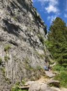
Rocher des Aravis
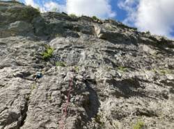
Interesting rock climbing area for routes up to 5c, from 6a to 6c and from 7a to 7c (french grades).
![Information](/images/attention.png)
Many additional skills about progressing, belaying, escaping technics ... are necessary for multipitch routes security.
Best time(s) : - January
- February
- March
- April
- May
- June
- July
- August
- Sept.
- Oct.
- Nov.
- Dec.
Aspect(s) : SW-S-SE Altitude : 1450 m
Approach 15 min up hill. Kids friendly ? foot of the crag uneven for young kids.
Informations :
More than 100 routes, from 3a to 8a. Bolting : sport climbing
Max Height : 75 m.
Rock :
limestone.
Characteristic(s) : vertical
![Vertical](/images/vertical.png)
, slab
![Dalle](/images/dalle.png)
.
Type(s) of holds : crimps, cracks.
Locations :
Area :
France, Auvergne-Rhône-Alpes, Haute-Savoie (74), Annecy, Les Etages.
![Information](/images/readme.png)
1. Zoom in to get all the rock climbing places 200 km around.
![](/images/mm_20_green.png)
: Bouldering
![](/images/mm_20_orange.png)
: Single pitch
![](/images/mm_20_red.png)
: Multi pitches
![](/images/mm_20_blue.png)
: Deep water soloing
![](/images/mm_20_white.png)
: Differents kind of climbing
Rock climbing area GPS Coordinates : |
Latitude : 45° 52' 58" N |
Longitude : 6° 26' 56" E |
Sexagesimal & Orientation
|
|
Latitude : 45° 52' 58" |
Longitude : 6° 26' 56" |
Degrees, Minutes, Seconds (DMS)
|
|
Latitude : 45° 52.971' |
Longitude : 6° 26.947' |
Degrees, Décimal minutes (DM)
|
|
Latitude : 45.882848° |
Longitude : 6.449114° |
Decimal degrees (DD)
|
|
Parking lot GPS Coordinates : |
Latitude : 45° 52' 44" N |
Longitude : 6° 27' 5" E |
Sexagesimal & Orientation
|
|
Latitude : 45° 52' 44" |
Longitude : 6° 27' 5" |
Degrees, Minutes, Seconds (DMS)
|
|
Latitude : 45° 52.74' |
Longitude : 6° 27.089' |
Degrees, Décimal minutes (DM)
|
|
Latitude : 45.879002° |
Longitude : 6.45148° |
Decimal degrees (DD)
|
Area added by CA