")
")


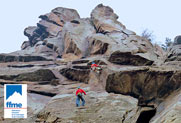
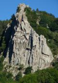
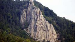
Rocher de Costaros

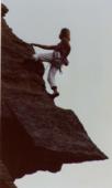
single pitch routes and multi pitch routes rock climbing area
Best time(s) :
- January
- February
- March
- April
- May
- June
- July
- August
- Sept.
- Oct.
- Nov.
- Dec.
Aspect(s) : SW-S-SE-E Altitude : 900 m
Approach 10 min up hill
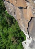
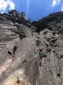
Rock :
phonolith. Characteristic(s) : slab  , vertical
  , steep wall
  , overhang
  , dihedral
  . Type(s) of holds : cracks, slopers.
Informations :
Single pitch routes
Interesting rock climbing area for routes up to 5c, from 6a to 6c and from 7a to 7c (french grades).
Between 50 and 100 routes, from 5a to 7b. Bolting : sport climbing.
Max Height : 38 m. Average Height : 28 m.
Kids friendly ? foot of the crag uneven for young kids.
Multi pitch routes
Interesting rock climbing area for routes from 6a to 6c and from 7a to 7c (french grades).
Between 25 and 50 routes, from 5b to 8a. Bolting : sport climbing.
Max Height : 80 m. Average Height : 60 m.
Kids friendly ? foot of the crag uneven for young kids.
Legendary route(s) : La Directe 5c/6a 3 longueurs
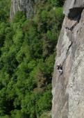
Further information(s) : This is a volcanic rock climbing area with 115 pitches on phonolite slabs and columns like "orgues". On each of the five sectors, you can climb:
- single pitch routes (<45m)
- 2 or 3 pitches routes with rappeling anchors.
50 km Southwest from "Saint Etienne" and 15 km North from "Yssingeaux". The area is East of "suc de Bartou".
Approach :
From the parking lot hike back to the hairpin curve. In this hairpin curve take a small tree-lined road. It turns to a path (GR path sign). You can see the rock from there. A less than 10 minutes approach.
Road access:
From "Saint-Etienne" city, head towards "Le Puy en Velay" by the RN 88, exit at "Yssingeaux", take "Retournac" direction, then in "Malataverne" go left the D7 towards Rosières. Two kilometers before Rosières turn right on the D35 towards "Chamalières sur Loire", drive 4 km then take a small uphill road on the left (Rocher de Costaros sign). 200m from the Varenne hamlet towards the Chomeil park your car.
Right part of the crag forbidden from begining of february to end of june (bird protection)
Locations :
Area :
France, Auvergne-Rhône-Alpes, Haute-Loire (43), Le Puy-en-Velay, Rosières, Chamalières-sur-Loire.
|
|
Latitude : 45° 11' 0" N | Longitude : 3° 58' 8" E | Sexagesimal & Orientation |
|
|
Latitude : 45° 10' 38" N | Longitude : 3° 58' 4" E | Sexagesimal & Orientation |
| More coordinates |
Area added by Jean-Phi