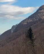
Rocher Blanc (Pyrénées-Atlantiques)
Interesting rock climbing area for routes from 6a to 6c and from 7a to 7c (french grades).
![Information](/images/attention.png)
Many additional skills about progressing, belaying, escaping technics ... are necessary for multipitch routes security.
Best time(s) : - January
- February
- March
- April
- May
- June
- July
- August
- Sept.
- Oct.
- Nov.
- Dec.
Aspect(s) : NW-N Altitude : 850 m
Approach 25 min up hill. Kids friendly ? foot of the crag uneven for young kids.
Informations :
Between 25 and 50 routes, from 4c to 7c. Bolting : sport climbing
Max Height : 100 m.
Rock :
limestone.
Characteristic(s) : vertical
![Vertical](/images/vertical.png)
, dihedral
![Dièdre](/images/diedre.png)
.
Type(s) of holds : crimps, cracks.
Locations :
Area :
France, Nouvelle-Aquitaine, Pyrénées-Atlantiques (64), Pau, Louvie-Juzon.
![Information](/images/readme.png)
1. Zoom in to get all the rock climbing places 200 km around.
![](/images/mm_20_green.png)
: Bouldering
![](/images/mm_20_orange.png)
: Single pitch
![](/images/mm_20_red.png)
: Multi pitches
![](/images/mm_20_blue.png)
: Deep water soloing
![](/images/mm_20_white.png)
: Differents kind of climbing
Rock climbing area GPS Coordinates : |
Latitude : 43° 5' 12" N |
Longitude : 0° 21' 43" W |
Sexagesimal & Orientation
|
|
Latitude : 43° 5' 12" |
Longitude : -0° 21' 43" |
Degrees, Minutes, Seconds (DMS)
|
|
Latitude : 43° 5.209' |
Longitude : -0° 21.718' |
Degrees, Décimal minutes (DM)
|
|
Latitude : 43.086823° |
Longitude : -0.361969° |
Decimal degrees (DD)
|
|
Parking lot GPS Coordinates : |
Latitude : 43° 5' 25" N |
Longitude : 0° 23' 25" W |
Sexagesimal & Orientation
|
|
Latitude : 43° 5' 25" |
Longitude : -0° 23' 25" |
Degrees, Minutes, Seconds (DMS)
|
|
Latitude : 43° 5.424' |
Longitude : -0° 23.432' |
Degrees, Décimal minutes (DM)
|
|
Latitude : 43.090401° |
Longitude : -0.39053° |
Decimal degrees (DD)
|
Area added by CA