Rattlesnake Point
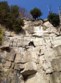
Interesting rock climbing area for routes up to 5c, from 6a to 6c and from 7a to 7c (french grades).
![Information](/images/attention.png)
Many additional skills about progressing, belaying, escaping technics ... are necessary for multipitch routes security.
Best time(s) : - January
- February
- March
- April
- May
- June
- July
- August
- Sept.
- Oct.
- Nov.
- Dec.
Aspect(s) : S-SE-E Altitude : 300 m
Approach between 10 and 60 min up hill then down hill
Informations :
More than 100 routes, from 5.10a to 5.12b , spread over many crags Bolting : sport climbing
Max Height : 30 m.
Rock :
limestone.
Characteristic(s) : overhang
![Surplomb](/images/surplomb.png)
, steep wall
![Dévers](/images/legerdevers.png)
, vertical
![Vertical](/images/vertical.png)
.
Type(s) of holds : crimps.
Park permit & waiver needed. No wrapping to trees!
Locations :
Area :
Canada, Ontario, Regional Municipality of Halton, Toronto, Milton.
![Information](/images/readme.png)
1. Zoom in to get all the rock climbing places 200 km around.
![](/images/mm_20_green.png)
: Bouldering
![](/images/mm_20_orange.png)
: Single pitch
![](/images/mm_20_red.png)
: Multi pitches
![](/images/mm_20_blue.png)
: Deep water soloing
![](/images/mm_20_white.png)
: Differents kind of climbing
Rock climbing area GPS Coordinates : |
Latitude : 43° 28' 2" N |
Longitude : 79° 54' 45" W |
Sexagesimal & Orientation
|
|
Latitude : 43° 28' 2" |
Longitude : -79° 54' 45" |
Degrees, Minutes, Seconds (DMS)
|
|
Latitude : 43° 28.038' |
Longitude : -79° 54.763' |
Degrees, Décimal minutes (DM)
|
|
Latitude : 43.467292° |
Longitude : -79.912716° |
Decimal degrees (DD)
|
|
Parking lot GPS Coordinates : |
Latitude : 43° 28' 15" N |
Longitude : 79° 54' 38" W |
Sexagesimal & Orientation
|
|
Latitude : 43° 28' 15" |
Longitude : -79° 54' 38" |
Degrees, Minutes, Seconds (DMS)
|
|
Latitude : 43° 28.26' |
Longitude : -79° 54.636' |
Degrees, Décimal minutes (DM)
|
|
Latitude : 43.471001° |
Longitude : -79.910599° |
Decimal degrees (DD)
|
Area added by Stolpy