Puig Campana
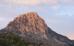
Interesting rock climbing area for routes from 7a to 7c and starting from 8a (french grades).
![Information](/images/attention.png)
Many additional skills about progressing, belaying, escaping technics ... are necessary for multipitch routes security.
Best time(s) : - January
- February
- March
- April
- May
- June
- July
- August
- Sept.
- Oct.
- Nov.
- Dec.
Aspect(s) : S Altitude : 700 m
Approach 60 min up hill. Kids friendly ? foot of the crag dangerous for young kids.
Informations :
Between 50 and 100 routes, from 4c to 7a , spread over many crags Bolting : traditionnal climbing, sport climbing
Max Height : 800 m.
Rock :
limestone.
Characteristic(s) : slab
![Dalle](/images/dalle.png)
, vertical
![Vertical](/images/vertical.png)
, dihedral
![Dièdre](/images/diedre.png)
.
Type(s) of holds : cracks.
Locations :
Area :
Spain, Comunidad Valenciana, Provincia de Alicante (d'Alacant), Benidorm, Finestrat.
![Information](/images/readme.png)
1. Zoom in to get all the rock climbing places 200 km around.
![](/images/mm_20_green.png)
: Bouldering
![](/images/mm_20_orange.png)
: Single pitch
![](/images/mm_20_red.png)
: Multi pitches
![](/images/mm_20_blue.png)
: Deep water soloing
![](/images/mm_20_white.png)
: Differents kind of climbing
Rock climbing area GPS Coordinates : |
Latitude : 38° 35' 22" N |
Longitude : 0° 12' 22" W |
Sexagesimal & Orientation
|
|
Latitude : 38° 35' 22" |
Longitude : -0° 12' 22" |
Degrees, Minutes, Seconds (DMS)
|
|
Latitude : 38° 35.371' |
Longitude : -0° 12.383' |
Degrees, Décimal minutes (DM)
|
|
Latitude : 38.589516° |
Longitude : -0.206379° |
Decimal degrees (DD)
|
|
Parking lot GPS Coordinates : |
Latitude : 38° 34' 55" N |
Longitude : 0° 12' 42" W |
Sexagesimal & Orientation
|
|
Latitude : 38° 34' 55" |
Longitude : -0° 12' 42" |
Degrees, Minutes, Seconds (DMS)
|
|
Latitude : 38° 34.932' |
Longitude : -0° 12.711' |
Degrees, Décimal minutes (DM)
|
|
Latitude : 38.582199° |
Longitude : -0.211846° |
Decimal degrees (DD)
|
Area added by CA