")
")


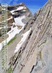
Pont d'Espagne (Le Péguère et le Ceriset)
Interesting rock climbing area for routes from 6a to 6c, from 7a to 7c and starting from 8a (french grades).
Best time(s) :
- January
- February
- March
- April
- May
- June
- July
- August
- Sept.
- Oct.
- Nov.
- Dec.
Aspect(s) : SE Altitude : 1300 m
Approach 10 min up hill. Kids friendly ? foot of the crag uneven for young kids.
Informations :
Between 25 and 50 routes, from 4c to 8b , spread over 3 crags Bolting : sport climbing
Max Height : 20 m.
Rock :
granite. Characteristic(s) : steep wall  . Type(s) of holds : crimps, slopers.
Locations :
Area :
France, Occitanie, Hautes-Pyrénées (65), Lourdes, Cauterets.
|
|
Latitude : 42° 51' 49" N | Longitude : 0° 7' 11" W | Sexagesimal & Orientation |
|
|
Latitude : 42° 51' 44" N | Longitude : 0° 7' 13" W | Sexagesimal & Orientation |
| More coordinates |
Area added by CA