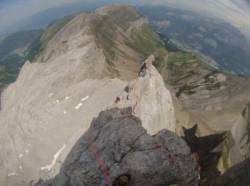
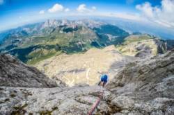
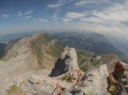
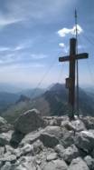
Pointe Percée
Interesting rock climbing area for routes from 7a to 7c (french grades).
![Information](/images/attention.png)
Many additional skills about progressing, belaying, escaping technics ... are necessary for multipitch routes security.
Best time(s) : - January
- February
- March
- April
- May
- June
- July
- August
- Sept.
- Oct.
- Nov.
- Dec.
Altitude : 2500 m
Approach 1h15 min up hill. Kids friendly ? foot of the crag dangerous for young kids.
Informations :
Between 25 and 50 routes, from 5c to 7b. Bolting : sport climbing
Max Height : 320 m.
Rock :
limestone.
Characteristic(s) : slab
![Dalle](/images/dalle.png)
, vertical
![Vertical](/images/vertical.png)
.
Type(s) of holds : cracks, crimps, limestone channels.
Further information(s) : Passer au refuge de Gramusset
Locations :
Area :
France, Auvergne-Rhône-Alpes, Haute-Savoie (74), Annecy, Le Bouchet.
![Information](/images/readme.png)
1. Zoom in to get all the rock climbing places 200 km around.
![](/images/mm_20_green.png)
: Bouldering
![](/images/mm_20_orange.png)
: Single pitch
![](/images/mm_20_red.png)
: Multi pitches
![](/images/mm_20_blue.png)
: Deep water soloing
![](/images/mm_20_white.png)
: Differents kind of climbing
Rock climbing area GPS Coordinates : |
Latitude : 45° 57' 20" N |
Longitude : 6° 33' 21" E |
Sexagesimal & Orientation
|
|
Latitude : 45° 57' 20" |
Longitude : 6° 33' 21" |
Degrees, Minutes, Seconds (DMS)
|
|
Latitude : 45° 57.34' |
Longitude : 6° 33.355' |
Degrees, Décimal minutes (DM)
|
|
Latitude : 45.955664° |
Longitude : 6.55592° |
Decimal degrees (DD)
|
|
Parking lot GPS Coordinates : |
Latitude : 45° 58' 12" N |
Longitude : 6° 31' 27" E |
Sexagesimal & Orientation
|
|
Latitude : 45° 58' 12" |
Longitude : 6° 31' 27" |
Degrees, Minutes, Seconds (DMS)
|
|
Latitude : 45° 58.206' |
Longitude : 6° 31.457' |
Degrees, Décimal minutes (DM)
|
|
Latitude : 45.9701° |
Longitude : 6.52428° |
Decimal degrees (DD)
|
Area added by CA