
")
")


Plättig
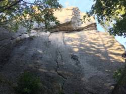
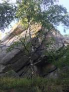
Interesting rock climbing area for routes from 6a to 6c and from 7a to 7c (french grades).
Best time(s) :
- January
- February
- March
- April
- May
- June
- July
- August
- Sept.
- Oct.
- Nov.
- Dec.
Aspect(s) : NW-W-SW-S-SE-NE Altitude : 750 m
Approach 15 min on flat ground. Kids friendly ? foot of the crag dangerous for young kids.
Informations :
Between 25 and 50 routes, from 3a to 7c , spread over many crags Bolting : sport climbing
Max Height : 50 m.
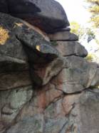
Rock :
granite. Characteristic(s) : dihedral  , vertical
  , slab
  . Type(s) of holds : pockets / holes, crimps, slopers.
Further information(s) : Hay que buscar muy bien pero hay vías de escalada.
Forbidden from january 1st to july 31st
Kletterverbot vom 01.01.-31.07.
Nur Jung-Kimmes-Türme und Kapellengels zum klettern freigegeben
Kletterverbot vom 01.01.-31.07.
Nur Jung-Kimmes-Türme und Kapellengels zum klettern freigegeben
Locations :
Area :
Germany, Baden-Württemberg, Karlsruhe, Baden-Baden, Bühl.
|
|
Latitude : 48° 40' 11" N | Longitude : 8° 13' 25" E | Sexagesimal & Orientation |
|
|
Latitude : 48° 40' 10" N | Longitude : 8° 13' 51" E | Sexagesimal & Orientation |
| More coordinates |
Area added by Sascha Eggs


