
")
")


Placas del Cura
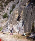
Interesting rock climbing area for routes up to 5c and from 6a to 6c (french grades).
Best time(s) :
- January
- February
- March
- April
- May
- June
- July
- August
- Sept.
- Oct.
- Nov.
- Dec.
Aspect(s) : W-SW Altitude : 350 m
Approach 1 min easy down hill then easy up hill. Kids friendly ? foot of the crag reasonable for young kids.
Informations :
Between 25 and 50 routes, from 4a to 6c , spread over many crags Bolting : sport climbing
Rock :
limestone. Characteristic(s) : slab  . Type(s) of holds : jugs, pockets / holes, crimps, water erosion pockets, tufas.
Further information(s) : Parking lot at the foot of the crag.
Whole family recommanded.
West side of Pico de La Concha.
Whole family recommanded.
West side of Pico de La Concha.
Locations :
Area :
Spain, Andalucía, Provincia de Málaga, Marbella, Istán.
|
|
Latitude : 36° 32' 39" N | Longitude : 4° 56' 22" W | Sexagesimal & Orientation |
|
|
Latitude : 36° 32' 40" N | Longitude : 4° 56' 22" W | Sexagesimal & Orientation |
| More coordinates |
Area added by Ras


