Pilier Saint-Martin
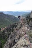
Interesting rock climbing area for routes up to 5c, from 6a to 6c and from 7a to 7c (french grades).
![Information](/images/attention.png)
Many additional skills about progressing, belaying, escaping technics ... are necessary for multipitch routes security.
Best time(s) : - January
- February
- March
- April
- May
- June
- July
- August
- Sept.
- Oct.
- Nov.
- Dec.
Aspect(s) : W-NE Altitude : 900 m
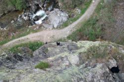
Approach between 4 and 10 min up hill. Kids friendly ? foot of the crag uneven for young kids.
Informations :
Between 10 and 25 routes, from 4a to 7a , spread over 2 crags Bolting : traditionnal climbing, sport climbing
Max Height : 100 m.
Rock :
granite.
Characteristic(s) : slab
![Dalle](/images/dalle.png)
, vertical
![Vertical](/images/vertical.png)
.
Type(s) of holds : crimps.
Locations :
Area :
France, Occitanie, Pyrénées-Orientales (66), Prades, Casteil.
![Information](/images/readme.png)
1. Zoom in to get all the rock climbing places 200 km around.
![](/images/mm_20_green.png)
: Bouldering
![](/images/mm_20_orange.png)
: Single pitch
![](/images/mm_20_red.png)
: Multi pitches
![](/images/mm_20_blue.png)
: Deep water soloing
![](/images/mm_20_white.png)
: Differents kind of climbing
Rock climbing area GPS Coordinates : |
Latitude : 42° 31' 36" N |
Longitude : 2° 23' 53" E |
Sexagesimal & Orientation
|
|
Latitude : 42° 31' 36" |
Longitude : 2° 23' 53" |
Degrees, Minutes, Seconds (DMS)
|
|
Latitude : 42° 31.605' |
Longitude : 2° 23.897' |
Degrees, Décimal minutes (DM)
|
|
Latitude : 42.526742° |
Longitude : 2.398276° |
Decimal degrees (DD)
|
|
Parking lot GPS Coordinates : |
Latitude : 42° 31' 41" N |
Longitude : 2° 23' 43" E |
Sexagesimal & Orientation
|
|
Latitude : 42° 31' 41" |
Longitude : 2° 23' 43" |
Degrees, Minutes, Seconds (DMS)
|
|
Latitude : 42° 31.692' |
Longitude : 2° 23.723' |
Degrees, Décimal minutes (DM)
|
|
Latitude : 42.528198° |
Longitude : 2.39539° |
Decimal degrees (DD)
|
Area added by CA